Khatling Glacier-Kedarnath trek

12 September 1987 to 23 September 1987 (parts of a diary)

14th – Reached Ghuttu by bus from Tihri, the beautiful oval shaped valley of which nothing would be left in years to come. Asia’s biggest dam and a hydel project have already been started. Two rivers flow into the valley. Bhilangana enters the Tihri valley from east and Bhagirathi from north-east. The dam iss being built on Bhagirathi while the Bhilangana water will be diverted through tunnerls from under the mountains. Bhagirathi water will be collected in Tihri valley bowl submerging the entire township. It is a pity… a new township is being built across on a flatter plain. People have been paid damages and different places alloted to them for residence but no one is ready to leave. Spent the night a Sarvodya school, a place where children are given free accomodation and education. Sleeping shack is mosquito infested, so couldn’t sleep till late at night.

Ghuttu: Sky is clearing up fast and heavy clouds have settled in the valley and are slowly floating around to find a way through the valley and upwards. People here are well aware of laws etc. they have had cases regarding land which have reached up to Allahabad High Court. The place that we are staying in ( a school building) was built in 1947 and has remained a primary school building ever since. Goats and sheep have just come into the verandah opposite us and are being pushed inside the lower cabins of the house. It is about 5 pm now and getting cold outside. Talking to these people is an alarming thing, so many problems – infertility, no postal service, no hospital or dispensery, broken bridges and children moving away from the village to towns. Village has 2 tailors but those are expensive, larger population is female, Rs 25 per kg rice. People destroying jungle in certain parts.

Pant is talking to them about various development projects of government sepecially about education and its benefits in terms of jobs and facilities and he is convincing the Pradhan about importance of reading and writing. Bachhan Singh Rana is the Pradhan of Gangi village.

Umrao Singh was jailed for illegal land occupation, took the case to Tihri and then to Lucknow and then to Allahabad High Court. Won the case and retained ancestral land, knows good english words and various Acts and their numbers etc. Studied up to class 5 in 1951 in Gangi Primary school operating since 1947. Has remained Primary since inception.

Morning tea at 5 and we started packing. Spent the night at Ghuttu PWD Rest House, comfortable cot but one blanket was too little for the night chill. Porters and Guide Tripan Singh came only at 7. Had breakfast and started trek with heavy back-pack. Tricky trek along the side of Bhilangana was of moderate exhaustion. 9Km trek up to Reeh valley was done by 11.30 and we planned to proceed to Gangi.. This stretch was through moist and slippery jungle. Friends saw snakes and deer.. lot of problems and issues with the porters who reached Reeh at 3 pm leaving no chance to proceed further to Gangi. Overcast sky and very chilly. Hot words with porters. Finally we went up towards the hutment area. Not a soul here, most of the huts are shut and locked, but the verandahs are open. Hot cup of tea and…. wonderful view of rain and clouds from our open “gallery”. Food is being prepared outside under a small rock shelter. Gangi 8500 ft.

Had nothing since morning so food was a welcome sign. Got rice and dal with baked potatoes, my nose is running and it is getting cold – drizzling – sometime a cloud moves away to let the sunlight fall on meadows and jungle opposite us. Shall be sleeping early. Rastogi, Singhal and myself are stacked in one of the verandahs.

15th – Reeh – Gangi 9km. Night at Reeh was not comfortable, choked nose and bad throat. Sloping floor made it all the more difficult to sleep. Got up at 5. Planned to reach Kalyani today but the porters are slow and adamant not to pace up. First 5 kms were a difficult steep ascent through dense wet forest of Rhododendrons and Walnut. Sun spares us for the first 3 kms as we were in the shadow of the hill but then it got very hot. On the way we stopped at a waterfall. Singhal started the bathing idea and then everyone lept into the bone chilling water. Cold is no word.. fresh from the bath gave us new zest to move faster. On the way came across two deserted villages of Nallana and Lalla, mere 20-25 huts in both but all locked and surrounded with full grown blooming Ramdana beans. Bright Red flowers with its seeds falling all around. But we are not supposed to touch them as it is not good “omen”. Last 4 kms were a mix of rolling up and down through the forest reaching this beautiful village of about 100 people who move down during winters and harvesting times in plains. Nice and happy people. Village has one shop for grocery etc. Went around talking to a few.

16th Gangi: Our guide Tripan (53) Singh is an experienced person on the route and promises not much problem crossing the Mayali Pass after Khatling. Very few trekkers do this route to Kedarnath. Only a couple of Bengali parties have visited Kedar from here. The upper reaches will probably have the maximum number of lakes, frozen or dry, anywhere else in the mountains. This village too, like others, has a good crop of Potato and Rajmah (red kidney beans). People are peeling fresh rajmah for drying. Entire village survives on farming and making wool thread from sheep hair. Rain has stopped and we can see many a rainbow scattered in skies over the valley. The green jungle background gives a heavenly look to the colours. Light is falling abruptly on woods across Bhilangana from the heavy clouds up almost on east-north-east while west and south are clear with beautiful sapphire blue sky. The villagers have had a session of Panchayat today with heated arguments and long discussion over a personal matter. All the elderly men have gathered on this massive stone verandah opposite the temple. Devi’s Bagghi is lying outside well decorated in bright red cloth and silver jewellery. Strangely few houses here have slate stone as roof, mostly it is wooden planks. The houses are two-tiered and the lower portion is for animals, fodder and other stuff needed during winter and rains. Otherwise the village has all the milk and food needed. Village Pradhan Shri Bachhan Singh Rana is now sitting with me and Pant discussing various problems like road building and deforestation. Government has sanctioned funds to build a motorable road up to Gangi but forest department is resisting it owing to both the mafia and in the name of deforestation. They are well aware of the current affairs and know about the current PM and President. They have transistors too but mainly for entertainment (songs and music) none is interested in other affairs.

16th – Village photography and meeting people. Our stay once again will be in a school hutment, so no pitching of tents. When we reached here about 15 children were being taught by a teacher. The place was broomed and cleaned for us. A cup of tea at one of the houses was really refreshing. Bhilangana is ferocious this side, cutting deep through north-east. It is raining now and the valley is covered with clouds all around. A child, Bahadur Singh is sitting with me and asking for a pen… he knows to write Hindi. The shed is leaking from all four sides, so all have huddled up in the centre. Plan to move early tomorrow.

17th Gangi- Tari Udiyar – 14km.. this morning we started for the toughest part of our trek taking us to Sahastratal. Starting at 7am the tricky path went along Bhilangana for about 5km, with a halt at Kalyani. Just before Kalyani there is a steep descent of about 500mt landing in front of a green meadow with just three huts (photo) A good view of the valley and snow covered peaks in front was a pleasure. Khichri and curd for lunch was a delight. Curd was bought from the villagers of Gangi. We were not expecting the terrible trek ahead. Almost a 70 degree ascent through dense jungle with no trail or indication of a beaten path was limb cracking. The villagers had warned us ‘rarely anyone goes up to Sahastra tal’. Two hours into the climb we came across what looked like a wall of  massive boulders scattered all around from where no way seemed to go up. Looking at them it seemed impossible to negotiate them. The porters made it up first climbing through cracks and niches and pulled our luggage up and we followed. Three hours of climb on steep mountain face took us to its ridge, which started another long and winding ascent over connected steep ridges which had nearly a thousand meter drop on both sides. A lesson in mountaineering and honing our climbing skills. From 12 noon to 7pm we kept crossing ridge after ridge, gaining height all the time and finally reached a tooth-like bent rock face jetting out of one of the rolling meadow. On the western face of it there were tin-sheets which created a shelter. As we entered it we realised it was a natural cave formation which had been extended with the help of tin sheets to create enough sleeping room for some 10/12 people. The place is known as Tari Udiyar (udiyar meaning cave or night shelter).

18th Tari – Shastratal (4.5km – 16740 ft) Tari to Kalyani (17km)

Given another choice I will never do it again, although it was the most fascinating of everything that I have done or seen yet. It was almost suicidal to have attempted Shastratal Lakes and the way back, steep descent over 11 ridges and rock faces in total darkness with not even a torch to see what were we walking or tumbling on. For once it was given up that night. Had some breathing issue in the middle of the night.

The shelter was cold but comfortable, dripping at a few places. Sat in the candle light and wrote a short poem. The morning ascent to started at 7am after light breakfast. In about an hour and a half we were amid the most stunning views of dozens of green water lakes dotting this area close to 17000 ft. Almost misty, clouds hanging so low, it seemed we were floating amid them. The mist was coming in waves, striking the snow covered slopes and settling over the lakes No sunlight, hundred of glacial melts coming from all sides feeding green water lakes. It is believed that this and the surrounding areas have over a thousand lakes, thus the name Sahastra. Depressions amid the cliffs around creating ideal lake forming situations. Weird shapes and sizes of numerous lakes that at time merge into each other. Virtually frozen region. Villagers from surrounding valleys come here to offer prayers. Visitors have left cow face like shapes at edges of the lakes which form small streams going down. The major lake is called Matra Tal and is a beauty. After a brief puja there, done by one of the porters we stared our journey back. The descent was not just slippery but terrible pain for the whole body… knees getting the worst of it. Morning dew, coupled with steep descent and boulder ridden path. After a light lunch at Tari, we started the descent. Looking down at the precipice of dangerous ridges and rock faces sent terror down everyone’s spine. Somehow made it to Bondi Udiyar after which one could see the real danger of slippery descent through wet  jungle floor. Slowly the Sun was setting in the west and we were heading due north. Thick and tall pine trees let very little light in. Even at 3pm it was getting dark all around. The needle-pine on jungle floor, covered with last nights’ dew, acted like a cushioned-skate-board under our feet. With nothing to hold we were skidding and falling like kids in the process of learning to skate. A few of us picked up Ringals (a thin variety of bamboo) to tap our way. No one could walk five steps without skidding and falling. In the process one would hit a tree trunk or a rock protruding out. It was very frustrating and slowly it got dark.. so dark that we couldn’t see each other. This is one evening of descent that no one will forget ever. In all there were three torches with the group but, lo and behold… none worked. We were hitting everything, boulders, tree trunks and each other. The lower outcrop in jungle tearing apart exposed skin. It was getting cold by the minute. We were cursing Trepan Singh and the porters. At times on all-fours.. the wet jungle soil must have created patterns of war-paint on our bodies. Just when we were in the last 2 km stretch Trepan Singh thought about the Kerosene oil being carried by us… he collected wet ringals, tied the gamchhas over them and created four “mashaals”… my my it was such a relief but too late.. at least the fear of the jungle subsided. Another 20 minutes and we reached back our camp at Kalyani. The journey back was so exhausting that no one even had the strength to get up and wash. Few rounds of chai around fire and then we went to wash our bodies and souls of that terrible descent. Rotti, allu and dal around campfire and most of us dozed off out in the open.

19th Kalyani [8700ft]– Kharsoli [9600ft] (11km) – After the terrible yesterday – it was kind of an easy day. Woke up late at 7.30, had breakfast and left for Kharsoli in warm and soothing sun-light. A little tussle about “bhaar” (the back-pack weight) with new porters hired at Kalyani. With our individual wet and heavy backpacks we started once again through dense jungle along Bhilangana flowing a little below to our right. The river is getting mightier and very noisy by the hour. Midway point was a kind of village, Virodh, with just one hut, probably for the PWD gang workers who look after the river embankments and trails in this area. Tea was made and enjoyed amid Bhoj and Kharso jungle and we started for the last stretch of 5km. Easy walk along the rolling track and we reached Kharsoli. Here too we find just one hut built amid very scenic surroundings. This 14×20 feet rectangular hut with pyramidical thatched top has bamboo partition around it. One one side we laid our sleeping mattresses and on the other a makeshift cooking area with fire. Rain time again, Kharso trees on north-west playing an orchestra of wind blown instruments… in between when the breeze stops, the echo of a flute or a whistle breaks the stereo effect together with the water drops hitting the leaves on jungle floor. Since this hut is under a big group of trees, its thatch is only wet in places which too soon evaporates with the smoke from our chullha. The side walls of bamboo held together with rope keeps cool breeze coming in, so smoke from kitchen fire quickly disperses, retaining the warmth inside.

20th – Kharsoli – Chowki (9km) – A little ahead of Kharsoli we crossed Bhilangana and were once again in the middle of thick jungle. Nearly 3km of climb amid steep rocky faces followed by easy walk and then a descent brought us to the heavenly green meadow of Chowki. Pitched tent facing a wall of huge peaks blocking our way on three sides. To our left was the lateral glacier Khatling about 3km away hidden in thick clouds… below which formed a lake of its glacial melt near our camping area, facing us some mighty peaks and the Dudh Ganga stream running to our right on south-east. The valley ahead to our right was where we had to proceed to Masoori tal and a peak of the same name. Arun Singhal is put off about something, dont know what. Since it was getting dark, we decided to visit the Khatling snout in the morning. Govind was bare foot all through the evening and he even went around the lake without shoes. We sat around the lake for nearly three hours till it got very cold and dark. On our way back we couldn’t even see our tents Came back to tent to have dinner. Sat on a large mound away from the tent and watched the silvery white peaks facing us, a certain pass is clearly visible between the peaks on my left, no one can say where it leads.

21st – Chowki to Masoori Tal – The morning was clear with sunlight breaking through the peaks in front. Starting at about 5 we reached Khatling snout around 6.30 over a boulder ridden moraine and scree. The clouds had started gathering again, but by the time we reached the snout, the peaks and glacier as if lifting the veil of clouds came right on our face. Shining bright in sunlight the Sphatik and Khatling peaks with the pass in the distance above was very clear. Kedar Dome to our north gave us a good opportunity for photo shoot. Plans were already being made to cross the Pass from the Gangotri / Kedar Tal side which is exactly behind this. As we moved higher we could see the Bhim Tal hidden behind the two ridges on our east. On our way back, while crossing the stream, Singhal slipped over a boulder and hurt himself. Not much but shaken a bit.

Had breakfast and wound up the Chowki-Khatling camp to proceed to Masoori Tal. A straight high ascent through boulders was hard to negotiate. The climb was very exhausting, ridge after ridge, pass after pass, breathless, the passage didn’t seem to end.. we were coming almost on level with the peaks to our left. Dudh Ganga glacier becoming clear and its flow didn’t seem like water but a white frothy milk deep down below. Back breaking loads forced us to stop at a small flat plateau with no sign of water around. Kedar Dome peak now distinct and its glaciers converging to meet Dudh Ganga glacier. Weather had cleared and on our left now we could spot peaks of Khera, the trio of Jogin 1, 2 and 3 together with Masoori peak. It is such a delight to be blessed with amazing views. Behind all this is the Gangotri water shed area of its own glaciers and valleys and peaks like Bhagirathi, Neelkanth and many more. Chilly winds swept our exposed area camping site bringing snow with them, temperature fell sub zero and then there was snow all around us.

22nd – Masoori Tal to Vasuki Tal (15,000 ft 14 km). Last night was very uncomfortable and cold. Couldn’t sleep a wink. Morning was chilly again and windy too. After light breakfast we moved towards Masoori Tal and Mayali Pass. Pious green waters of lake Masoori Tal were just a few hundred meters high surrounded on three sides by mighty peaks on our left. Climbing through the rocky face on east we ridge the top of the ridge to see an amazing view of Kedar Dome on north-east and Puniya glacier on right due-south. Three lakes make the base of Kedar Dome – Panya Tal – Puneeya Tal and Masar Tal. Continuing our trek we descended on Mayali (Puniya) Glacial ice-field for about 2 km, walking south, south-east. Walking on soft fresh snow, we were in nearly knee-deep snow, slowly climbing up to the hardened ice. Our shoes were not meant for this hence all were slipping back and progress was slow. Sun was now shining hard above us creating more problems as the snow started melting and the reflections off the glacier blinded us. Close to the Mayali pass we were at nearly 18000 feet. After the first patch of glacier, Ganga and two porters moved ahead to tie a rope to help everyone manage the next ascent. It was such a relief to reach the pass and the view on the other side was another breath-taking moonscape all the way down a boulder ridden steep slope. Two small lakes to our left greeted us. Huge boulders blocked our way.. it seemed an earthquake had hit this area sometime back. The sheer vertical drop towards Vasuki Tal was amazing. Slipped a few times over boulders, falling and jumping across, we reached Vasuki Tal by 4.30 pm. Another serene lake covered by hills all around. Towards the ridge on the east one could see cairn formation indicating the pass from where we had to get down towards Kedarnath.

23rd – Vasuki Tal – Kedarnath The evening spent at Vasuki was a memorable one. Much singing and dancing culminated with a few games of cards in the tent. Did two rounds of Vasuki Tal. Somehow the night wasnt as bitterly cold as the previous ones. Despite all the hardships the last day of an adventure is always painful. Reaching Kedarnath meant the trek was over. Once again we will be back to the same rut, the same polluted towns and cities, fumes and chaos, work and the daily grind. It was a sunny morning as we lazed around the tent while the porters were packing the tents and other stuff. Nothing will be needed from this today onward. Three rounds of tea and leisurely breakfast. Backpacks ready, the Pass in sight, we slowly moved towards the narrow eastern edge of the lake meeting the glacial melt coming down the pass. Our initial climb was along the stream coming down and after about half a km we moved left over a stiff climb through small boulders. The Pass was never out of sight. It took us nearly three hours to slowly trudge up the ridge meeting Kedar Dome. The top was wind-swept but sunny. From the top of the pass we could see the tiny structures of the habitation scattered around Kedar Nath temple and glacial melt coming down from Gandhi Sarovar from between Kedar peak and . The sheer vertical drop was scary. There was no trail and it seemed nearly 75 degrees. One had to be very careful, a stupid mistake or the shift of the load to front would mean rolling down non-stop for a kilometer or two. Short measured steps, carefully kept one by one, ensuring that the foot will not slip made the progress slow. But who was in a hurry. While the porters were wanting to rush we deliberately slowed down, stopping every ten minutes, sitting and enjoying the peaks facing us. We took a lazy two hours to touch the grounds across Kedar Nath temple. Crossing the bridge we faced the crowds once again after 12 days. It was 4 pm. Crossing the narrow bazaar we approached the temple, sitting in its precinct we thanked the Lords. A few rounds of chai in the bazaar and shopping for tid bits to carry home. An hour later Trepan Singh came back having fixed the place where we would be spending the night. Plans were being shared for the journey back home. Except Singhal and me everyone wanted to stay an extra day at Kedar Nath. We wanted to get back home to Delhi and Chandigarh soon. It was decided that Singhal and me would leave at day break to ensure that we reach the road head well before the last bus left. A comfortable night followed a hot water bath next morning. We were out, ready with our backpacks at 8 am. Friends lined up for last hugs and byes. It was a race against time to cover 16 km down to Gauri Kund and catch the 3 pm bus. We ran… yes literally ran down the wide trail, slipping and balancing over loose wet soil, over the pony poo strewn over smooth pebbles and rocks embedded in the trail. We didnt stop even for one minute any where, not for water, not for tea or munchies. Our heads down, eyes fixed to the trail, not deviating by a degree for the fear of landing any false step, our knees crackling, shoulder torn by rucksack straps, backs seeking forgiveness… there were intermittent showers in patches. Pulling our caps over the foreheads we looked at each other and gave a silent confirmation that we will keep going… and we did. Singhal would look at his watch once every 10 minutes as we were in the last two kilometers, smiling to himself all the time. I knew we were not far from Gauri Kund as no one was climbing up any more… which meant it was past noon, when pilgrims are not permitted to go up. When we hit the real metalled road, Singhal stopped and looked at his watch, he turned looked at me and gave me a big hug pushing the watch in my face. The time was 1.47 pm. We had done the incredible. Having done 16 km down hill in less than six hours. Tickets to the bus purchased, we washed and sat down to have lunch. Trust me, after that half an hour of sitting on the bench our legs refused to carry our load or straighten. We were walking like pregnant women.

Members of the expedition
Govind Pant Raju – Leader 27 March 1959
Ganga Singh Martolia – Deputy 8 August 1957
Prahlad Singh Burphal 8 August 1958
Puran Singh Jangpangi 6 November 1955
Ravi Tandon 1 July 1958
Prem Shankar Shah 29 May 1957
Gopi Sonkar 6 July 1957
Rajendra Nath Rastogi 14 July 1948
Arun Singhal 18 July 1955
Rajinder Arora 25 April 1956
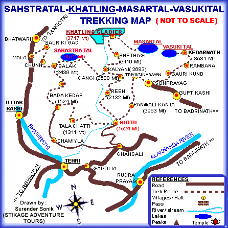
khatling map

Love Raj Singh Dharmshaktu on Everest for the 7th time

When you were busy damaging your knuckles, ruining your wrists and shoulders, bent over that laptop, preparing your next PPT, an Excel sheet or a marketing plan to ensure the five or six figure salary – you were oblivious that an unassuming, media shy man from Bona village of Kumaon, Love Raj Singh Dharmshaktu, had quietly crept up Mt Everest (8858m) for the SEVENTH time yesterday. Yes, for the 7th time… the only Indian to have run up and down the highest point so many times as if it was a morning jog. Along with him were six other members of his team flirting with the clouds on top of the world.

Having first climbed Everest in 1998, Love Raj repeated the feat in 2006, 2009, 2012, 2013, twice in 2017 once again for the seventh time on 20th May 2018. Besides Mt Everest Love Raj has climbed, in all, 38 peaks including the fearsome Kanchenjunga (8586m).

My first meeting with Love Raj was in the lovely hamlet of Munsiyari (Pithoragarh distt) of Kumaon in August 1989 when we were making final preparations for our expedition to Mt Nanda Kot (6861m) overlooking the Longstaff Col and twin peaks of Nanda Devi.

All of sixteen years at that time, Love Raj Singh was still in high school and had tagged along the expedition with his cousins ‘just for fun’. He wasn’t even a part of the group to begin with. I don’t remember if he had even been on a high altitude trek before that, leave aside a full scale expedition. Honoured with Padma Shri in 2014, Love Raj Singh did his basic mountaineering course a year later in 1990. It had been drizzling through the afternoon and the evening was rather chilly, yet Love Raj was wearing a thin cotton shirt and had rubber slippers in his big feet with no socks. Standing in the veranda outside the cottage where we were staying, the two of us were admiring the snow covered Panchchuli massifs only a few kilometre from us. He was so shy that he barely conversed. His mettle was proven over the next one month when he was always the first one to head for the next camp with a heavy load and virtually bereft of any gear. He didn’t even get the climbing boots as the expedition was short of them. No ice-axe, no thermal jacket, a very ordinary pair of dark shades covered on sides with cloth and tape to protect against the UV exposure. An innocent smile never left his face, his laughter saved the moment in toughest of situations, and, his lyrical rendition of Kumaoni songs of love and longing evoked pleasant emotions dissipating physical distress in cold and cramped tents. Despite all odds (two accidents towards the end, broken bones and rib cages, frost bites and shortage of ration) the expedition was a success. We summited in mid September. The happy go lucky lad of Nanda Kot expedition is now a phenomena in Indian mountaineering, Salute to your courage, determination and achievements Comrade and Friend Love Raj Singh may you achieve all that you attempt. Just like your name, spread Love.

Our Nanda Kot expedition was led by the iron-lady of Indian mountaineering Padma Shri Chandra Prabha Aitwal (then 57 years of age). Nine members of the team successfully climbed Nanda Kot after much struggle at and beyond Advance Base Camp due to heavy snow-fall and avalanches rolling down the nearby Changuch peak, in which the ABC was destroyed; equipment and ration was irretrievably buried and for nearly a week all of us thought that the weather gods were not in a mood to let us climb. We retreated and waited patiently at the base camp only to be rewarded with what was desired. But, that is a story for another day.

As if not content with his own exploits Love Raj chose Reena Kaushal, as his partner and wife, herself a successful mountaineer, having led many an expeditions. Adrenalin filled adventurer that she is, Reena Kaushal holds the record as the first woman from India to ski to the South Pole from the coast of the Antarctica. Cheers to the two of you.

May 21, 2018

  1. “Nanda Kot, 1989. On August 21, 1989, our Base Camp was placed above the highest village Lawan at Lachhmanpatti at 14,000 feet. Advance Base was occupied at 16,000 feet on the 26th. During the night it began to snow and kept on until the 28th when we retreated to Base Camp. When the weather cleared on August 30, we went up again and shifted Advance Base further up. Camps I, II, III and IV were set up on September 1,3,4 and 5. On the 6th we reconnoitered to an ice wall. The ridge leading to the summit was narrow. Nine of us gained the summit of Nanda Kot (6861 meters, 22,510 feet) on September 8, 1989. Two others came up directly from Camp III and we helped them to reach the top.” – from another post sometime in 1992.

तुम जाओ, लौट जाओ

एवेरेस्ट से वापसी पर नामचे से फकडिंग को नीचे उतरते हुए जब आखरी बार एमा डबलम को देखा था तो पहेली आठ लाइन लिखी थी। तब से एक बरस तक इसे पूरा नहीं कर पाया। शायद तारिख 4 या 5  मई 2016 थी।  आज फिर से वही कुछ याद आ गया सो पूरी कर दी।

तुम जाओ,
लौट जाओ
में नहीं आऊँगी।
न तुम्हारे साथ
ना पीछे,
तुम लौट जाओ
शहर को
अपनों के पास।
तुम्हारा प्रेम
बस पहाड़ों से है
तुम्हारी लालसा
उचाईयों की है
तुम्हे
कुछ पाना है
देखना है
छूना है
लिखना है
और
लौट जाना है।
तुम नहीं जानते
महसूस करना,
किसी का होना
और
किसी का हो कर
बस, रह जाना .
टिक जाना
रुक जाना
हो जाना विलीन
दुसरे में।
मेरा अपना
कोई नहीं है
न है कोई अस्तित्व।
मुझमे एक दो नहीं
अनगिनित आत्मा हैं
इस ब्रह्माण्ड सी
आकाश गंगा सी
और उस से भी परे की
अथाह ऊर्जा की।
में बर्फानी हवा हूँ
नहीं रह पाऊँगी
ऊंचाइयों से
बर्फ से
पहाड़ों से
परे या दूर।
मैं उड़ती हूँ
वादियों में
बहती हूँ
झरने और नालों में।
नदी सी
पूरक नहीं हूँ मैं।
न ही जाती हूँ
समंदर से मिलने
तुम जाओ,
लौट जाओ
में नहीं आऊँगी।
में बादलों में घुली
फुहार हूँ
उनका आकर हूँ
आसमां का वंश हूँ
हिम हूँ
भाप हूँ
कल्पना हूँ।
सागर से दूर
फ़िज़ां में घुला
हर औरत का
दिवास्वप्न हूँ।
तुम जाओ,
लौट जाओ
में नहीं आऊँगी।
रास्ते की
सबसे छोटी
कंकरी हूँ मैं ।
गिरी
पिसी
रुंधाई।
चमकती
स्फटिक हूँ
जो चुभेगी तुम्हे
पैर में
आँख में
दिन में – रात में।
तुम जाओ,
लौट जाओ
में नहीं आऊँगी।
में बूटी हूँ, जड़ हूँ
चट्टानी दरारों में।
महक हूँ
सूखे चटक में।
बिन बीजा
दोष हूँ।
झूठे अमरत्व सी
दवा हूँ।
तुम क्या, मुझे
सब चाहते हैं
तो ?
मैं कँहा हो सकती हूँ
सब की !!!
तुम्हारी  !!!
तुम जाओ,
लौट जाओ
में नहीं आऊँगी।
न तुम्हारे साथ
ना पीछे।


Cities.Towns.Places.Memories.

छुक-छुक गाड़ी की खिड़की के उस तरफ़ तेज़ी से पीछे भागते दरख़त जैसे आदम जात से डर के छुप रहे हैं

<GT Road> On highway, running parallel to train track, a yellow car has a piece of white cloth fluttering like a torn flag. Possibly the sign that the next city has made peace with me.

<Ambala> On rail stations of towns from past, memories are hanging in ceiling corners swinging in cobwebs.

<Chandigarh> Layers peeling off, memories like old wound, surface again

<Morni Hills> Just two ridges of Shivalik, and behind them are the lower Himalayan mountains. Can almost smell them. Goosebumps.

( 12 February 2016, train journey from Delhi to Solan and Barog)

A mysterious pass amidst the clouds

Dhumadhar Kandi Pass and Yellow Tooth
“We are in love with each other Mountains and I…” – Li Tao Po

It was the beginning of yet another summer and yet another call from the mountains. Sitting in the humid Delhi office I was toying with the idea of planning an elaborate expedition while scanning the pages of Indian Mountaineer number 25 when a feature on Dhumadhar Kandi Pass caught my attention abruptly.

Reading the article over and over again I was almost transported to the inner sanctum of Himalayas, treading the unknown wonderland, exploring and enjoying the most closeted beauty of mother nature. The more I read and reread the accounts of earlier expeditions, the nearer I reached to an almost conclusive idea of visiting the Banderpoonch area.

In 1815, JB Fraser, on his way to Gangotri collected information about Dhumadhar Pass. From his Journal of Himalayan Travel we came to learn that Sian gad (a tributary, which meets Bhagirathi from the north-west near Harsil village) rises in Dhumadhar – a very lofty and wild range to the north of Banderpoonch and along which there is a very alarming road leading to remote parts of Rawaeen’. In those ancient days, the villagers/traders used to cross this pass from Sian valley to arrive at the villages in the valley of Kinnaur by crossing the easier Borasu Pass (5151m) to the bordering U.P. (Uttarkashi) and H.P. (Kinnaur).

The existence of the Dhumadhar Pass has also been indicated in the old Topo Sheet of the Survey of India published long before the independence of India. There the Pass is marked on the first part of the ridge that initially turns south from the eastern end peak (5875m) of Swargarohini range and leads to a high point c5530m named Barasukha. The second part of the ridge then moves south-east to a prominent rock pinnacle known as Yellow Tooth (5740m). Finally the ridge semicircles and proceeds through Kalanag (Black Peak) and other two Banderpoonch group of peaks to the south. The Ruinsara Gad, the main source of Tons river originates from the Banderpoonch glacier below this sprawling range and flows north-west through a narrow valley separating the two principal ranges of Swargarohini and Banderpoonch to the north and south respectively.

Beyond the Swargarohini range, Gibson’s ‘veritable fairyland’ – the Har ki Doon exists. This lush green valley is drained by three turbulent streams which combine to form Har ki Doon Nala. The Nala then meets Ruinsara Gad a few kilometres above Osla, the last village of the Upper Tons Valley. These combined streams form the Tons river which continues its journey to join the Yamuna far below near Kalsi.

In recent past the first known attempt to Dhumadhar Pass was made by a Calcutta team led by Amulya Sen in 1972. From Seema (Osla) they made five camps and launched an attack on the second part of the ridge close to Yellow Tooth. Their attempt was foiled by inclement weather and poor snow condition. Next year a small team, also from Calcutta, led by Sudhan Bose attempted on the same part of the ridge. The leader met with an accident and injured himself badly. Two members and porters of the team claimed to have reached the Pass which appeared in Himavanta (March 1974) but faced severe criticism as the ‘Account is by no means convincing’ (Himavanta May ’74). The third recorded attempt was in 1984 by a two member team composed of SS Mukherjee and G Santra also from West Bengal, from the reverse direction (Himavanta March ’85 and Indian Mountaineer Spring ’87). From the confluence of Sian and Gantraro Gads they followed a tributary to the south west to arrive at a glaciated field below the watershed. They finally gained the ridge keeping close to Yellow Tooth and planted a rectangular slate stone on the ‘depression’ as evidence of their crossing. They descended along an eighty degree snowy scree slope which they thought to be the ‘only feasible route’ to the Tons (Ruinsara) valley”.

In one of my meetings with Govind Raju in Delhi sometime in July, we had discussed the possibility of attempting Yellow Tooth and crossing over the Dhumadhar Kandi Pass in the Upper Tons Valley. He too had a similar plan in mind and we got cracking on the expedition. A couple of phone calls to various enthusiasts and we were a small but strong team, all set to leave by last week of August.

The initial plan was to approach the peak and the pass from the normal western side of Tons Valley through Sankri, Osla, Ruinsara Tal and Swargarohini base. Our arrival in Uttarkashi and a final rerun on the plans we shifted our attention from the western to the eastern side of the pass/peak. The reasons were many – mainly the paucity of time, shorter approach to our main objective, reaching the peak and the pass fresher and in better shape than being fatigued by the very long march from the western end – and most importantly of being able to explore the route from eastern side since not much was known about the area.

Considering all possibilities we decided to embark from Jhala, a little hamlet about 50 km short of Gangotri. With the help of local friends and well wishers, we managed to gather all essentials and organised a happy-go-lucky team of porters and a guide at Uttarkashi, in about two days. Though we deeply missed our friend and guide Himalaya Sherpa (a great guide and an excellent climber), yet we couldn’t have waited for him since he had gone with another expedition in Gangotri area. On September 4 we left Uttarkashi for Jhala.

Bus journey to Jhala too had to give us its own share of memories. First one of the tyres got punctured – 45 mins of delay and the bus started moving and then when we were just short of Gangnani the axel broke while the bus was on a patch where the road was climbing steeply. Suddenly the bus first stopped with a jerk and then started rolling backwards. It was because of the presenece of mind of the conductor who jumped out and pushed a big stone behind the tyre that the reverse motion was halted. Half of us had already started thinking of the worst. A new axel had to brought from Uttarkashi, so the driver had to rush back taking lifts. We made best use of the time first writing letters than walking upto Gangani where we drowned our souls in the hot sulphur waters in the kund. Cups and more cups of tea with pakoras lifted our spirits. By the time the bus was back in action it was clear that we will have to spend the night at Jhala only. Considering everything we decided to drop the porters at Jhala and proceeded to Gangotri in the same bus to spend the night there and come back the next morning after offering prayers at the Gangotri temple.

At night Gangotri and its surrounding hills have a different magic. The ferocious Bhagirathi prevails — it is music, meditation and noise at the same time. In the filtering moonlight the water-sculpted contours of Gourikund cast a magic on the observers. We stood on the bridge for a while before proceeding to Gharwal Mandal rest house. First bus in the morning brought us back to Jhala by 8 am.

By the time we left Jhala on September 5 it was 10 am, and deep inside the village we could hear the conch shells and bells announcing the preparations were for puja of the village deity. We crossed the village and proceeded close to the banks of Sian Gad. For the next few days we will have to be along Sian and the rocky terrain to its right. From here we had to climb a steep 2500 ft almost 75 to 80 degrees. Last few days of rain had covered it with moss, tall grass and thick bushes. The steep climb did not pose much problem since there were good foot holds. Reaching atop the final bend on the ridge we had a last look at Bhagirathi valley and slowly descended into the narrow Sian Gad gorge. The climb up, though very steep and tiring, wasn’t as dangerous as the descent over a very narrow rock face which at times was less than 8 inches with a sheer drop of over 2000 ft to our left. The worst was the algae and wet growth on the rock which had become very slippery because of constantly dripping ledges atop us. One mistake or a wrong foot would have taken us for a free jump into the abyss. Once through with the rocky area we landed in the dense tall grass which was at times over seven feet high giving us no idea of the route ahead. The morning rain had left a lot of water accumulated on them too and walking through them we too were drenched. The climb now wasn’t steep but the tall grass caused enormous problems of an unexpected kind. We had done almost nine km by now when suddenly there came a heavy downpour and we could see the lightning through the dense jungle on our left. To our rescue was this sole Bhoj tree in a little clearing under whose grace we found some relief. Rain just didn’t seem to stop, we were drenched, cold and tired. It was decided to look for a camping area nearby, which was not be. A small clearing was made in tall grass amid mud puddle and soaking ringal grass (a thin bamboo like growth) and we were forced to camp amid filthy surroundings full of musquitoes and a host of other insects. Pitching just one tent all of us huddled in it and waited for the rain to subside. That night it rained nonstop and we couldn’t sleep a bit, dripping tent made night more miserable as it soaked our sleeping bags too.

The morning after (Sept 6) conditions were still bad, there was no sign of Sun and there were dense black clouds all over us. The rain had subsided but it hadn’t stopped. It as decided to wait till 11 am and then decide the course. We had an extended breakfast with many cups of tea. By 11 rain had nearly stopped, we quickly packed an moved. The track was just like the last day with a lot of slippery areas, mud deposited on slippery rock faces, thorny bushes, tall grass and the constant fear of rock fall because of the rain. Barely an hour later it started pouring all over again. It was windy and getting very cold too. Soaked clothes and equipment had added on to the weight, even in the small streams enroute the water level had increased so much that it was becoming difficult to ford them. By three in the afternoon we decided to halt at a point called Talla (lower) Kiyarkoti.
Today we got to know our porters a little more who were a great moral booster to all of us. The foursome, all Neapalese, were quite a mixed lot. Til Bahadur, a happy-go-lucky character, the strongest of them all was an experienced porter having participated in quite a few mountaineering expeditions including Nun-Kun; Nain Bahadur was a very quiet person and a workoholic – you wont see him sitting idle or even taking rest; for Nand Bahadur it was his first time out on a trek, he had appeared for high school exam in Nepal, and was working to part finance his studies which he wanted to continue; and lastly was Kali Bahadur who probably had an unending source of joy and laughter within him. His face was never devoid of a smile whatever may be the circumstance.
The camp site was much better in the open ground close to a stream though amidst a thick Bhoj jungle. By 4:00 the rain had stopped and slowly the rays of Sun infused life into all of us. We had a good time by the side of a camp fire which we lit pretty early, having collected the broken branches all around us. A sumptuous dinner continued while drying wet clothes and warming dampened souls. A clear night lulled us to sleep and we woke up very fresh the next day.

We still had to cross the Sian Gad further up Malla (upper) Kiyarkoti where two streams coming from the western glaciers of Yellow Tooth and Banderpoonch merge with Sian. With the last two days rain and the bright sunshine today the water level had increased dramatically and the current was very swift. We didn’t want to take any risk in crossing the turbulent river so we decided to walk along the right side of river looking for a possible point to ford it easily. Climbing further up for nearly 2000 feet, we did not find a single point where we could cross it without risking. Further up from here was the glacier with its moraines and yawing crevasses. After a lot of deliberation we decided to camp at the edge of the glacier. We also decided that the height gained today, in an attempt to cross the river, will be used to our advantage by going straight towards the Yellow Tooth glacier tomorrow instead of having to descend again. We had done only nine kms. Some villagers in Jhala also call Sian Gad as Jhotthi Nadi (the Liar river). According to them this river should be crossed in as much time as you take in one breath because it takes very little time for water to increase or decrease in this river. We did not know we will have to live it too, how true are some of the local sayings in Himalayas, it was proved today. Till late evening we were exploring the shallow points and pushing big boulders inside the stream in an attempt to create a possible crossing point.

Next morning (Sept 8) we woke up very early. By 4:00 am the entire party was ready to take on the river, the current didn’t seem fearsome though water very very cold. We roped up taking extreme caution and one by one carefully crossed over to the other side. Warming the frozen limbs we had breakfast and saw that the vegetation was giving way to lichen and high altitude flowers in small hardy bushes. We were constantly walking on moraines and loose rock, which made progress very slow and very tiring too. It was close to 15000 ft; dry air, lack of oxygen and cold winds were making the task more difficult.

By 2:45 pm we were at a point where the long ridge connecting Banderpoonch to Swargarohini was in front of us as a wall, giving us the view like a well displayed upmarket window, yet tucking away in a corner some of the precious gems and the key to the unknown. We decided to camp here and plan our schedule to attempt the Pass from here the next morning.

Attempting twice, through different routes, on loose moraines we ended up in front of a massive ice field with gaping crevices all around us. Despite having roped up and negotiating the hard ice field and having climbed over 1000 feet we could not spot a possible depression that could have been crossed by a local or even a fairly experienced trekking team. Further ahead we could see this massive ice wall which did not provide any route. Three of us and two porters started step cutting in turns slowly over this hard ice. After two hours (and about 200 meters of step cutting) we gave up the unrewarding attempt. It was realised that without fixing a rope it would not be possible for us as well as the porters to carry the loads any further. We could not have attempted the Pass without them since we had to cross the ridge and go over to the Har ki Doon side, which was another four days trek. We realised that the route and direction we had followed was everything but right.
We decided to descend and attempt the north-western face to our left. Precious time had been lost besides my friend and group leader Govind Pant broke his ice axe in cutting the hard ice. After a brief rest we started walking up the north-west side but soon realised that even this was leading us to a wrong direction. The hard climb yet again led us to another ridge without any depression in site. Though we were tired and frustrated, yet none wanted to give up. It was decided to make a third attempt towards the western slopes of Dhumadhar, This route seemed very dangerous. We descended almost 2000 feet on loose scree and moraine and then climbed almost 1500 feet in four hours. We were now at about 17500 ft height on Dhumadhar and could look across — facing us on the east was a very deep gorge descending almost vertically, and we could not even figure out the route further on; there was no way we could think of going down this route. The constant fear of a stone hit kept us on the edge of our nerves even on this third attempt, and we decided to descend towards Yellow Tooth. After losing almost 2200 feet we were at a flat, though very windy, patch from where we could closely inspect the entire ridge in front of us.

Though it was a safe place but the high wind caused enough problems for us to pitch tents and even in preparing food. Worst there was no water source close by, we had to melt ice to drink and to make tea. By the evening we had recced the true passage to the Col and we were sure of making it the next day. The scene in front of us was just amazing, a large crescent of ridge connecting the Yellow Tooth, Kalanag, Bunderpoonch peaks and stretching far to our right as far as we could see. Far in the distance one could faintly spot Sudarshan Pk and all around were scary glaciers. A bizarre place. Night was very uncomfortable, high speed winds coupled with nearly minus 20 degree temperature and the uneven rocky surface did not let us take even a nap.
We began at 5 next morning, carefully negotiating loose almost hanging rock ledges. There was a constant flow of loose stone from the ridge on our right. Having moved nearly a thousand feet to our left we almost came to a crater like point from where Yellow Tooth was barely a few hundred feet away from us. Early rays of Sun on a clear day were playing their magic on this yellow rock peak making it appear like molten gold and a clear azure blue sky devoid of any clouds creating a perfect background to the ochre yellow. Another one hour of slowly climbing towards the ridge and there we were! The dream land before us. We were atop the Dhumadhar Kandi Pass. It was precisely 9:38 by our watch. A lot of cheering, hugging, celebrations, puja, unfurling the tri-colour and national anthem had kindled the dying embers of our group’s enthusiasm. The thrill of having made it instantly erased the memories of the dangerous trek up. Where we were standing was also not a very safe place, yet we wanted to enjoy it and kind of remember every rock around us for as long as we could. A major photo session ensued. A few feet to our right was this massive rock projection about 6 to 7 meter high precariously balancing hundreds of small rocks. Between us and the Yellow Tooth was only this short ridge. Kalanag (Black peak-Banderpoonch) could now be seen clearly; a great display of Swargarohini range; and in front of us as the dangerous Banderpoonch glacier spread for miles below.

Standing on the edge of the escarpment ridge overlooking the wall, I recollected the account of JTM Gibson as quoted by Praful Kumar Ganguly in Indian Mountaineer number 25. “This charming vale is ideal for trekkers and mountaineers where some unclimbed ridges, high passes and virgin peaks still offer challenges. The majestic Swargarohini (6253m), dominating as the highest peak in the range that stretches out from west to east at the northern flank, remains virgin till date and the formidable Dhumadhar Kandi Pass (5608m) on the Tons-Bhagirathi divide at the eastern rim of the valley, has been ever mysterious for its tricky location, dizzy height and unstable weather conditions.”

Two days of hard work finally bore fruit when we were ready to begin the descent from the Pass. The loose rocky ridge had enough red signals for us. Getting down wouldn’t be easy – was spelt out in the very first few steps – when two of our porters set-in the chain reaction for rolling boulders. A word of caution from the leader once again had all of us conjuring all possible disasters of a descent in such a region. The snow field about 200m down was tempting us to have a go – but the progress was quite slow. Once near the snow field we realised what more lay ahead. Yawning crevices and a long tongue of the glacier little ahead couldn’t have been friendly to anyone.
Despite all precautions and care we still had our share of the slips and missed heartbeats but thankfully nothing serious or unfortunate happened. We were happy that we made the right decision of having approached the Pass from the eastern end since the route ahead had many more problems than anticipated.

The scenario reminded me of the Tibetan plateau to the north-east where similar ranges were slowly crumbling and the rocky terrain was equally risky. From the Banderpoonch base till the Ruinsara Tal along the Banderpoonch Glacier, with Swargarohini hidden to our right, we were walking on almost no track – the path taken by earlier expeditions to Banderpoonch had completely been washed off leaving no trace of the direction to follow. At a lot of places some tricky bends had us clinging to the rock edges and at times bringing us on all fours.

Fortunately for us, the weather gods were in our favour for not once did the clouds threaten us or the showers dampened our spirits. Slowly trudging the tricky area we were in safe haven at Deobasa camping ground and then it was like a race to be with the so called civilised world once again. The camping ground around Ruinsara Tal and the leftover Bhoj jungle was better than the best alpine meadows that we had ever seen or heard of. Yet our dear porters would not want to camp there because a few days back one of the climbers who had died on Banderpoonch glacier was buried in the same ground. A few moments of rest and we walked past the heaven to reach a camping site about three kilometres downstream. It was a makeshift hut of herb collectors, who would bring and sift through the day’s collection here and probably stay here for a few days, till finally proceeding down to village Osla/Seema. The mystery of Dhumadhar had indeed been unveiled.

Team: Govind Raju (Leader), Rajinder Arora, Jagdish Singh Basera, Laxman Rana and Kamal Sahi

Assisting porters: Til Bahadur, Kali Bahadur, Nand Bahadur and Nain Bahadur